Premium 24-inch full HD display with pinch-to-zoom touchscreen control has the
highest resolution on the marine market
Configure the full system to provide 1-touch setting access for docking,
cruising, fishing, anchoring, and more
Beautiful glass helm look with the ability to install multiple displays either
flush or flat-mounted edge-to-edge
High-performance processor delivers our fastest map drawing ever and enhanced
video processing
Provides a superior user experience across your entire network for radar,
sonar, and multimedia
GPSMAP 8424 large-format multifunction display features a 24-inch full HD
screen with touch control. The sunlight-readable, anti-glare display is
exceptionally easy to view and includes an auto-dimming feature for low light
or at night. The maximum glass design lets you experience a beautifully
powerful, completely networked helm at your fingertips. In-plane switching (IPS)
LCD - an industry first for this class - provides consistent, accurate colors
from all viewing angles. It also provides standard USB touch output for use as
a touchscreen monitor for Windows® and Mac® operating systems. Install
multiple displays with the industry's lowest flush-mount profile or flat mount
them edge-to-edge to create a sleek glass helm look. Quick, 1-touch access to
the information you need makes boating easier.
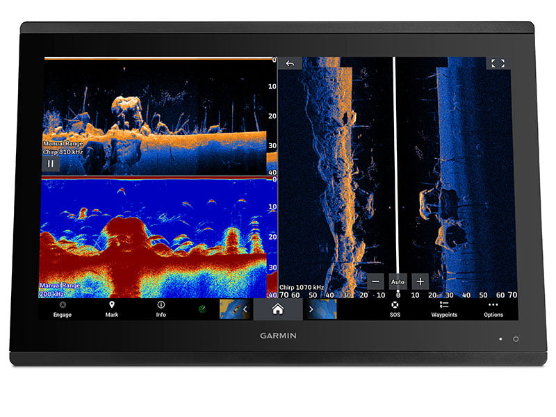
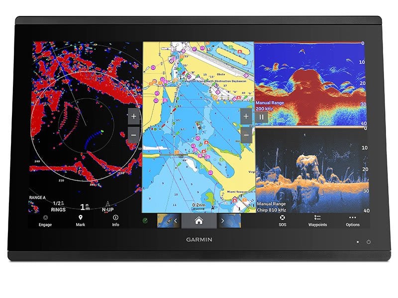
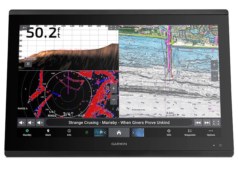
TRADITIONAL AND SCANNING SONAR SUPPORT
Get built-in support for 1-kW Dual-Channel CHIRP traditional sonar for
superior target separation and ClearVü
and SideVü scanning sonars to see up to 1,000’ below and around your
boat at 260 kHz (requires transducer, sold separately).
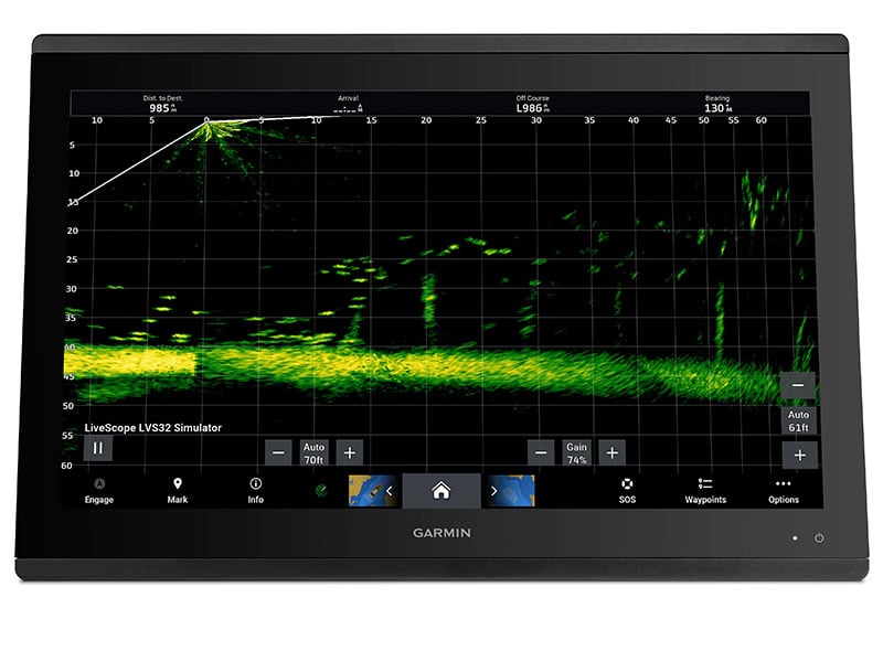
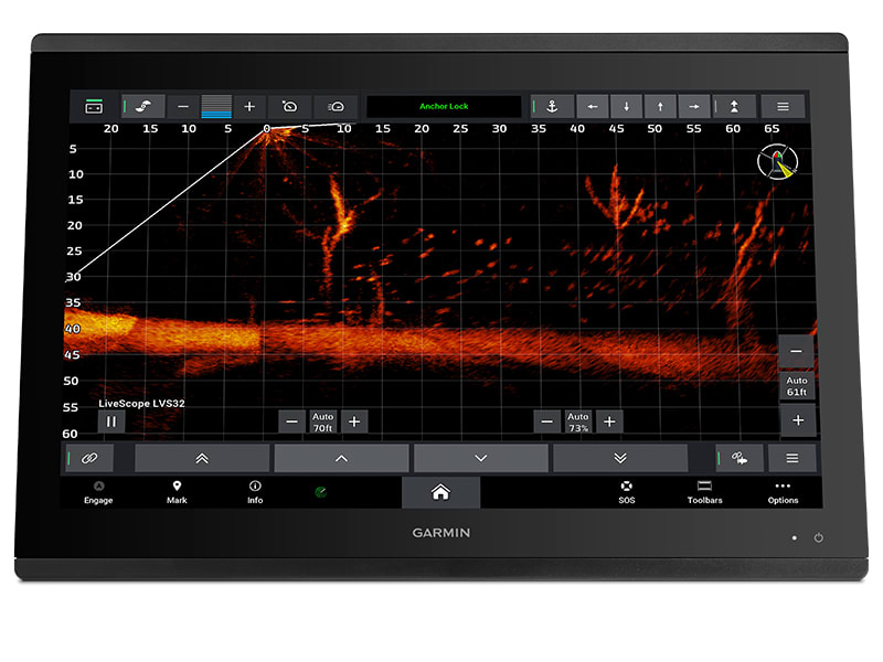
LIVE SONAR SUPPORT
Pair your chartplotter with Garmin live
sonar options (transducer sold separately) to see all around your boat
in real time.
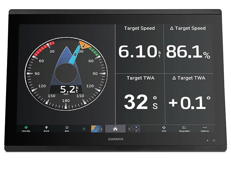
GARMIN SAILASSIST™ SAILING
FEATURES
View laylines, race start line guidance, enhanced wind rose, heading and
course-over-ground lines, true wind data fields and tide/current/time
slider, wind angle, set and drift, wind speed, polars and more.
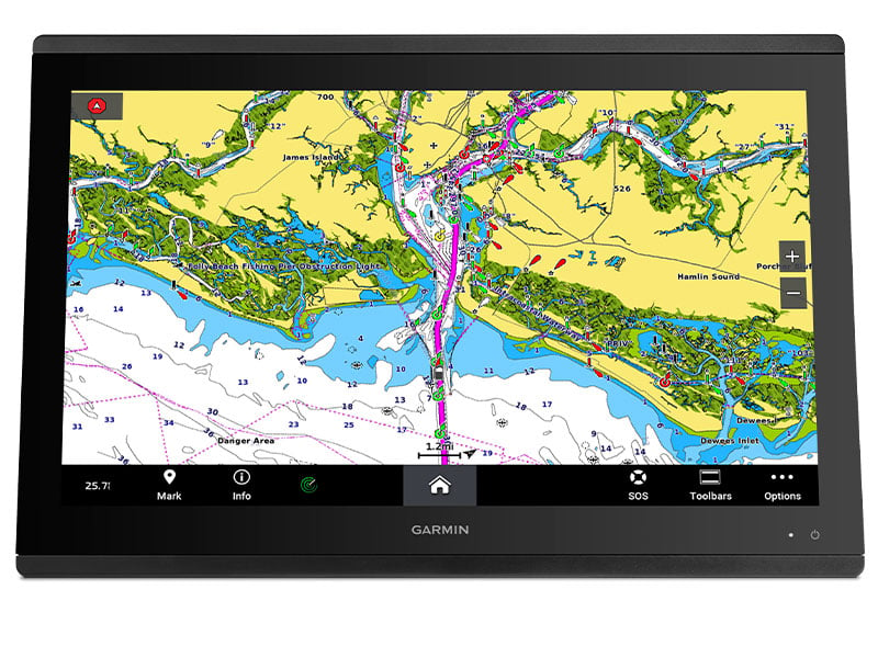
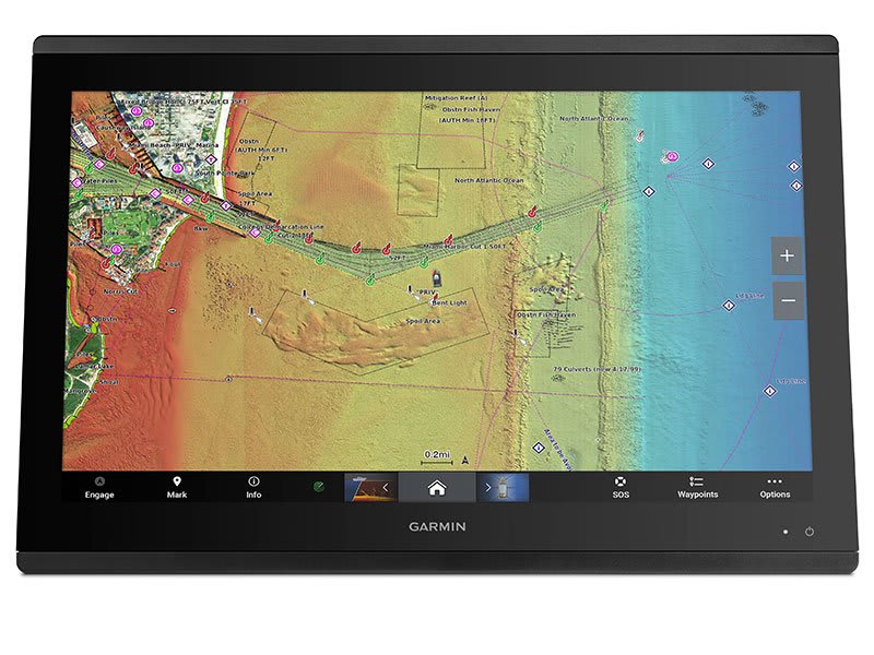
PRELOADED MAPPING
Experience unparalleled coverage and detail with built-in Garmin
Navionics+™ integrated
coastal and inland mapping that includesAuto
Guidance+™ technology2 and
a 1-year subscription for downloadable daily updates and more on select
chartplotters.
OPTIONAL CHARTS AND MAPS
Bring a fresh new look and feel to your chartplotter with optional upgrade
to Garmin Navionics Vision+™ premium
chart subscription, featuring downloadablehigh-resolution
relief shading, satellite imagery, sonar imagery and more.
SAILING POLARS
Use the polar table to see key data, including how fast you should go at a
certain wind angle and speed — so you know whether you need to adjust sail
trim.
GARMIN MARINE NETWORK
If you have multiple compatible Garmin devices on your boat, you can share
information — such as maps, user data, radar and IP cameras — among them.
NMEA 2000® AND
NMEA 0183 NETWORKS
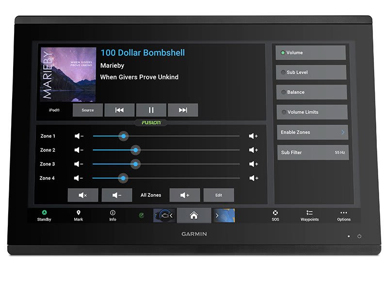
Connect to autopilots, digital switching, weather, FUSION-Link™ audio
system, media, VHF, AIS and more from one screen.
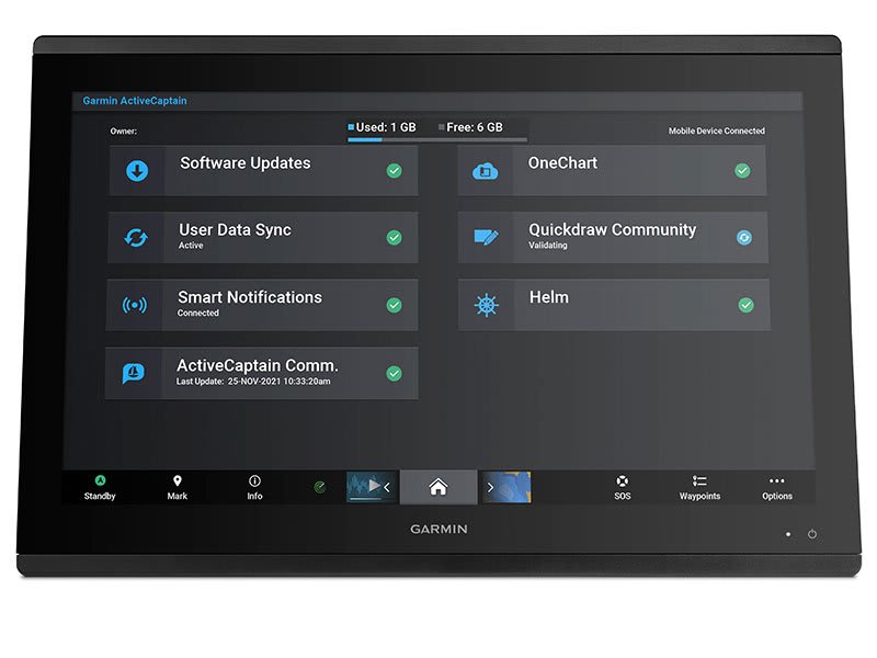
ACTIVECAPTAIN® APP
Built-in Wi-Fi® connectivity
pairs with the free all-in-one mobile app for access to theall-in-one
mobile app for access to the OneChart™ feature,
smart notifications3 ,
software updates, Helm,Garmin
Quickdraw™ Communitydata
and more.
INTEGRATED BLUETOOTH® AND
ANT TECHNOLOGIES
Connect with some of your favorite devices, such as quatix® marine
watches,gWind™ Wireless
2transducers, GNX™ Windmarine
instruments and wireless remote controls.
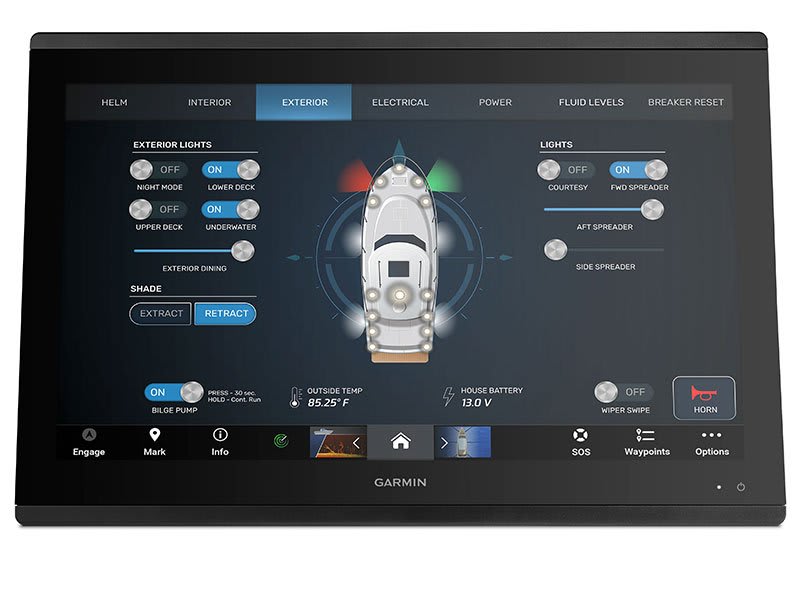
ONEHELM™ FEATURE
This feature brings
together all the operations and capabilities of third-party devices, such
asEmpirBus™ digital
switching, on one screen.
SMARTMODE STATION CONTROLS
Get quick, one-touch access to the information you need to ease
high-stress situations such as docking. You can incorporate networked
sonar, radar, cameras, media and more.
POWER-POLE® SHALLOW
WATER ANCHOR
By networking select Garmin chartplotters with a Force® trolling
motor and your compatible Power-Pole shallow water anchoring system, you
can access advanced boat control features5 from
your plotter, including smart anchor auto-deployment, smart anchor jog,
auto stow, anchor drag detection and auto guidance6 end-of-route
anchoring. Spend more time fishing, less time positioning.
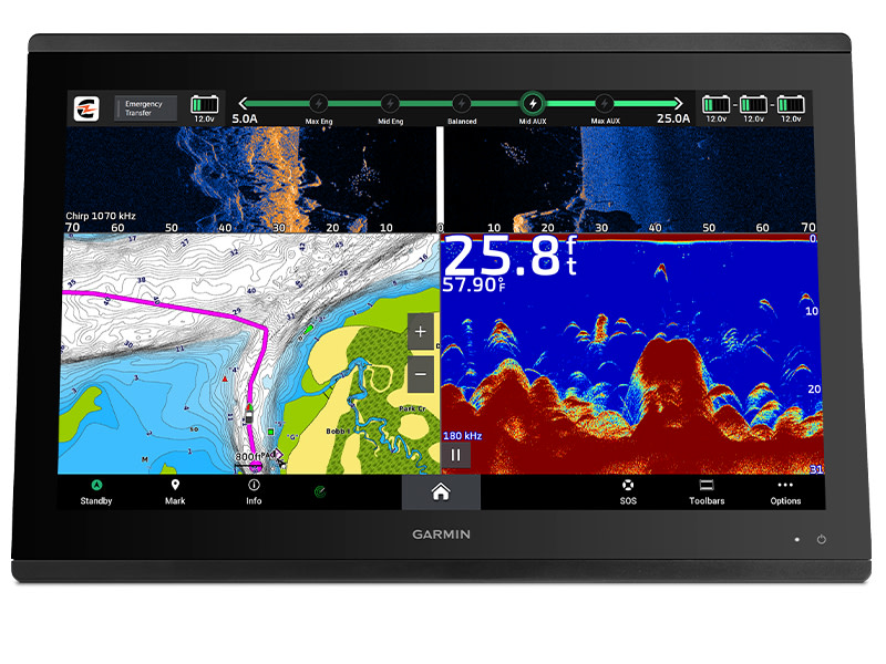
CHARGE INTEGRATION FROM POWER-POLE
Your CHARGE Marine Power Manager from Power-Pole integrates with
compatible Garmin chartplotters to help keep your battery power going
longer and stronger on the water. You’re able to charge batteries on the
run, monitor power use, select where power is allocated, control emergency
starts and even transfer power between battery banks — all from your
chartplotter display.
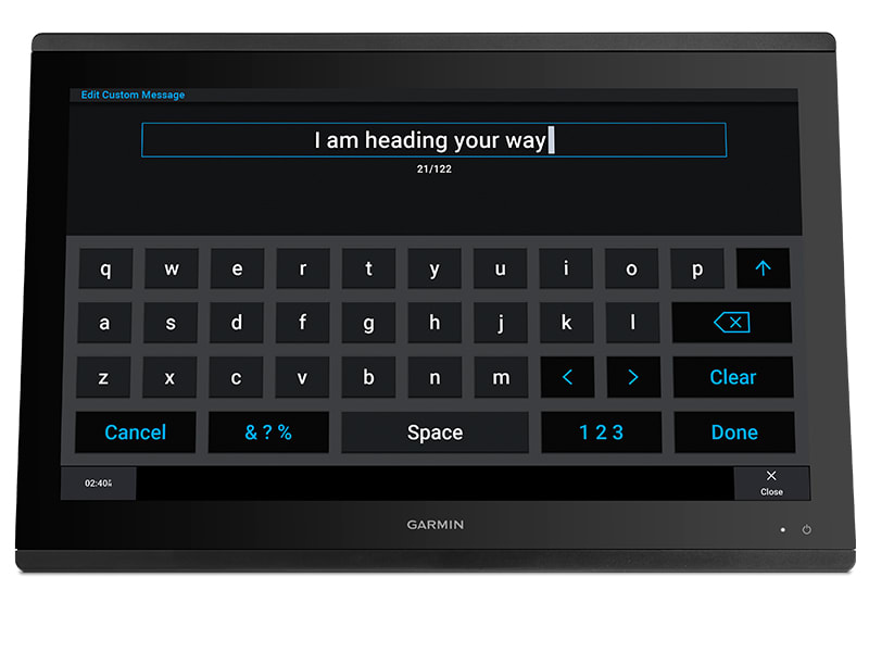
SEND INREACH® DEVICE MESSAGES
Pair your inReach satellite communicator4 to
your chartplotter, and type custom messages using your MFD’s on-screen
keyboard. Access your contact list or enter an email, inReach address or
phone number. You can also group messages by conversation for a texting-like
experience.
Full System Integration
GPSMAP 8424 integrates various sonar technologies, autopilot, connectivity,
apps, engine data, and multi-media. User data can be automatically synced for
all networked 8400/8600 series chartplotters across multiple helms - everything
you need is at your controls are available right at your fingertips either at
the helm or programmed into a remote key fob or an app on your tablet provided
by CZone by Mastervolt.
High-Performance Processor
Experience the fluidity of our fastest map drawing ever and enhanced video
processing. Add up to 4 IP camera streams and simultaneous Garmin Helm™ support.
In addition, all your added sensors, such as radar, sonar, multimedia, and more,
will benefit from the increased performance to provide a premium experience
across your boat's entire network.
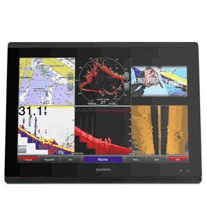
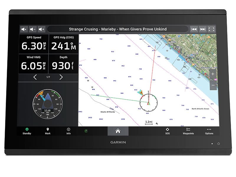
Customize Layouts with SmartMode™ Control
To make boating easier, GPSMAP 8424 includes presets for sonar, radar, cameras,
media, and digital switching, which can be independent or incorporated into
SmartMode. With SmartMode control, you can quickly change all screens at a helm
in sync to a preset mode, for example, fishing, docking, night cruising, etc.
One-touch access allows you to switch all monitors in sync from 1 mode to
another without manually switching each monitor separately. Fully customizable
layouts, data, and gauges allow you to place the information you need to see
right where you want it.
Garmin Marine Network & NMEA 2000® Network Support
Full-network compatibility allows you to add more to your boat. GPSMAP 8424
supports radar, autopilot, instruments, multiple screens, FUSION-Link™
entertainment system, sensors, remote sonar modules, digital switching,
weather, thermal cameras, GRID™ remote devices, and more. It's also FLIR camera
compatible and provides SiriusXM support.
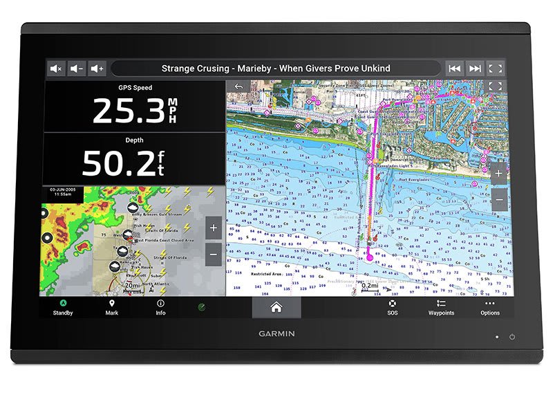
View Multiple Sonar Sources Simultaneously
GSD™ 26 CHIRP professional sonar, GSD 24 advanced sonar, and GCV™ 10 or GSD 25
DownVü and SideVü scanning sonar, even Garmin Panoptix™ all-seeing sonar, can
exist on the same system. You can view various sonars together on 1 monitor or
across multiple monitors in multi-display systems.
Add Array or Dome Radar
You can add your choice of Garmin marine radar, including our powerful xHD2
open-array radars, GMR Fantom™ open-array radars with MotionScope™ technology,
or xHD dome radars that pair ease of use with advanced open-array features.
Network Sharing
GPSMAP 8424 allows you to share features with other compatible GPSMAP units such
as radar, supplemental maps, and user data, including waypoints, routes, and
tracks. You can also share images from Garmin VIRB® action cameras, GC™ 10
marine cameras, and FLIR cameras. User data entered into 1 chartplotter can be
automatically synced with other chartplotters in a network.
Heading, Position Refreshed 10 Times Per Second
Fast, responsive built-in 10 Hz GPS refreshes your position and heading 10 times
each second to make your movement on the screen more fluid. Now, it's quick and
easy to drop up to 5,000 accurate waypoints and find your way back to them.
SailAssist Features:
Supported sailing features include laylines, enhanced wind rose, heading and
course-over-ground lines, true wind data fields, and tide/current/time slider.
Racing features include pre-race guidance, synchronized race timer, virtual
starting line, time to burn, and layline data fields. Gauge displays are
designed to provide important, need-to-know information at a glance, including
true and apparent wind angle, set and drift, true or apparent wind speed,
horizontal or vertical graphs, and a data bar with customizable data fields.
Create Your HD Maps
Quickdraw Contours is a free, easy-to-use software feature that is already
installed on your GPSMAP 8424. It instantly creates your very own personalized
HD fishing maps with 1-foot contours. Tailor them to fit your needs. They are
your maps. You own them. Keep the data to yourself or share it with Garmin or
your friends. There's no special surveying expertise required. You just fish
while it creates maps. You don't have to wait around or send your files away
like other mapping software requires - your results appear instantly. Quick
Contours automatically selects the most capable sonar device to provide the very
best results for you!
Optional Charts and Maps
Bring a fresh new look and feel to your chartplotter with optional Garmin
Navionics+™ or premium Garmin Navionics Vision+™ cartography featuring
integrated coastal/inland content, access to daily updates, Auto Guidance+™
technology2, and more.
FUSION-Link Entertainment System
Enjoy the ability to control all compatible FUSION-Link-enabled audio systems
directly from your compatible chartplotter display.
Physical & Performance
Dimensions
22.8in x
16.1in x 2.8in (60.0 cm x 41.0 cm x 7.1 cm)
Display
size
20.4in x
12.8in (51.8 x 32.5 cm)
Display
resolution
1920 x 1080
pixels
Display
type
Touchscreen
IPS display (anti-glare finish)
Water
rating
IPX7
Antenna
External
only
NMEA 2000
compatible
Yes
NMEA 0183
compatible
Yes
SiriusXM™
Weather & Radio compatible
Yes
Power
consumption
Max power
usage at 10 Vdc: 87 W
Typical current draw at 12 Vdc: 6.1 A
Max current draw at 12 Vdc: 7.6 A
Mounting
options
Flush or
Flat
Garmin
marine network ports
4
Maps & Memory
Preloaded
maps
None
Accepts
data cards
2 SD Cards
(with Garmin SD card reader accesory)
Waypoints
5,000
Routes
100 (250
waypoints each)
Track log
50,000
points; 50 saved tracks, with 5000 points each
**The price is subject to change at anytime without any notice. We
are not responsible for any typographical errors. Any products can be
cancelled from sale at any time.
** All Products sold here are Brand New unless specified
Otherwise and come with Full Manufacturer's Warranty
WARNING:
This product can expose you to chemicals including Di-n-hexyl Phthalate (DnHP)
which is known to the State of California to cause reproductive harm, and
Vinyl Chloride which is known to the State of California to cause cancer. For
more information go to P65Warnings.ca.gov.
__________________________________________________________________________________________


