
Garmin GPSMAP 943 Chartplotter GN+
GPSMAP® 943 Chartplotter GN+
You’re a boater who wants premium features, maps, and charts for your connected helm. This crisp 9" high-resolution chartplotter makes that wish come true.
Get a sharper view from your connected helm with the GPSMAP® 943 chartplotter. Its higher-resolution 9” in-plane switching display has 50% more pixels than previous-generation chartplotters. The ultra-sleek design and nearly double the processing power of previous-generation GPSMAP devices offer seamless integration into your Garmin marine system.
Preloaded Garmin Navionics+™ coastal charts and inland mapping feature Auto Guidance+™ technology (Auto Guidance+ is for planning purposes only and does not replace safe navigation operations) for helping you get where you need to go.
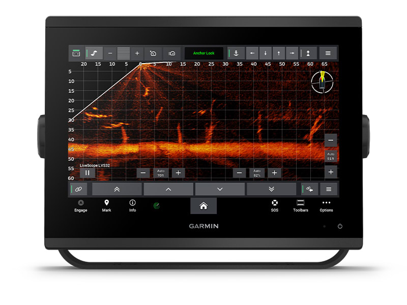
Plus, there’s support for optional Garmin Navionics Vision+™ premium map content. Easily build your marine system — from compatible sonar and autopilots to compatible radar, cameras and multimedia — by using HTML 5.0, NMEA 2000® and NMEA 0183 networking, J1939 for engines, and the Garmin Marine Network. Add FrontVü™ forward-looking sonar (sold separately) for help in avoiding underwater obstructions ahead. Or pair your plotter with your other compatible Garmin devices, such as quatix® smartwatches, wind transducers, wireless remote controls, and more.
FASTER, SHARPER, SMARTER
With its added processing power and new slimline design featuring
edge-to-edge glass and a smaller unit footprint, it’s easy to retrofit
this plotter in a wider range of dash configurations.
IMPROVED DISPLAY OPTICS
New higher-resolution IPS
displays for 9” and 12” plotters offer improved sunlight readability
and visibility from any angle, with 50% more pixels than
previous-generation 9” GPSMAP devices.
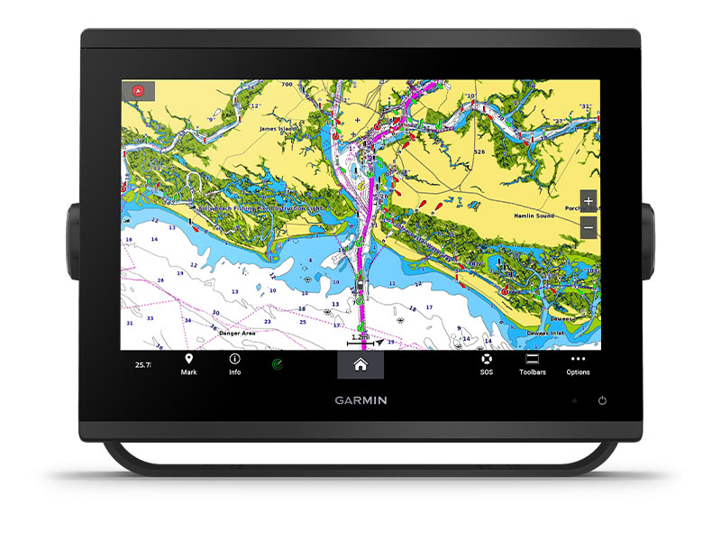
PRELOADED MAPPING
Experience unparalleled coverage and detail with built-in Garmin
Navionics+ integrated coastal and inland mapping that includes Auto
Guidance+™ technology3 and
a 1-year subscription for downloadable daily updates and more on select
chartplotters.
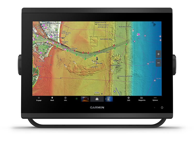
OPTIONAL CHARTS AND MAPS
Bring a fresh new look and feel to your chartplotter with optional
upgrade to Garmin Navionics Vision+™ premium
chart subscription, featuring downloadable high-resolution
relief shading, satellite imagery, sonar imagery and more.
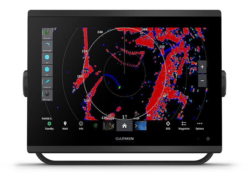
OPTIONAL RADAR BUNDLE
To help you avoid weather and traffic on the water, the compact 4 kW GMR™ 18
HD3 dome radar is available as a bundled option with
your GPSMAP chartplotter/sonar package.
POWER-POLE® SHALLOW
WATER ANCHOR
By networking select Garmin chartplotters with a Force® trolling
motor and your compatible Power-Pole shallow water anchoring system, you
can access advanced boat control features6 from
your plotter, including smart anchor auto-deployment, smart anchor jog,
auto stow, anchor drag detection and auto guidance7 end-of-route
anchoring. Spend more time fishing, less time positioning.
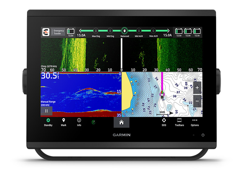
CHARGE INTEGRATION FROM POWER-POLE
Your CHARGE Marine Power Manager from Power-Pole integrates with
compatible Garmin chartplotters to help keep your battery power going
longer and stronger on the water. You’re able to charge batteries on the
run, monitor power use, select where power is allocated, control
emergency starts and even transfer power between battery banks — all
from your chartplotter display.
|
Features:
- Higher-resolution in-plane switching touchscreen display offers improved sunlight readability and visibility from any angle, with 50% more pixels than previous-generation 9” units
- Fast and responsive, with nearly twice the processing power of previous-generation GPSMAP® devices, this system references 10 Hz GNSS (GPS, GLONASS, and Galileo) for accurate positioning and smooth speed as well as COG data
- Slimline display borders, edge-to-edge glass, and reduced unit footprint make for easy retrofit in a wider range of dash configurations
- Preloaded Garmin Navionics+™ coastal charts and inland mapping feature Auto Guidance+™ technology (Auto Guidance+ is for planning purposes only and does not replace safe navigation operations) ; plus, there’s support for optional Garmin Navionics Vision+™ premium map content.
- Built-in Garmin SailAssist™ features, including laylines, race features, set and drift, wind data and more. Requires compatible wind transducer (sold separately)
- J1939 engine connectivity for easy integration with engines and our exclusive OneHelm™ feature for connecting to your compatible third-party devices, such as EmpirBus™ digital switching
- Easily build your marine system — from compatible sonar and autopilots to compatible radar, cameras and multimedia — by using NMEA 2000® and NMEA 0183 networking and the Garmin Marine Network
- Use built-in Wi-Fi® networking to pair with the free ActiveCaptain® smartphone app for access to the OneChart™ feature, smart notifications, software updates, and more.
- Integrated ANT® connectivity support for use with compatible quatix® smartwatches, the gWind™ Wireless 2 transducer, GNX™ Wind marine instrument, and wireless remote controls
Specifications
|
General
|
|
PHYSICAL
DIMENSIONS
|
9.2" x 6.4"
x 3" (23.3 x 16.2 x 7.6 cm)
|
|
DISPLAY
SIZE
|
7.8" x
4.4"; 9.0" diagonal
|
|
DISPLAY
RESOLUTION
|
1280 x 720
pixels
|
|
DISPLAY
TYPE
|
WXGA
display
|
|
WEIGHT
|
3.6 lbs
(1.6 kg)
|
|
WATER
RATING
|
IPX7
|
|
POLARIZED
SUPPORT
|
Yes
|
|
POWER
CONSUMPTION
|
Max power
usage at 10 Vdc: 22 W
Typical current draw at 12 Vdc: 1.3 A
Max current draw at 12 Vdc: 1.8 A
|
|
ANTENNA
|
Internal or
external over NMEA 2000
|
|
MOUNTING
OPTIONS
|
Bail, flush
or flat
|
|
RECEIVER
|
10 Hz
high-sensitivity
|
|
GARMIN
MARINE NETWORK™ PORTS
|
1
|
|
Maps & Memory
|
|
PRELOADED
MAPS
|
Garmin
Navionics+ offshore, coastal and inland water charts for the U.S. and Canada
|
|
ACCEPTS
DATA CARDS
|
2 microSD™
cards (back of unit)
|
|
WAYPOINTS
|
5,000
|
|
TRACK LOG
|
50,000
points; 50 saved tracks
|
|
ROUTES
|
100
|
|
Outdoor Recreation
|
|
TIDE TABLES
|
Yes
|
|
Chartplotter Features
|
|
GARMIN
RADAR COMPATIBLE
|
Yes
|
|
GARMIN
SONAR COMPATIBLE
|
Yes (with
external black box, sold separately)
|
|
GARMIN
SMARTMODE COMPATIBLE (CUSTOMIZABLE MONITOR PRESETS)
|
Yes
|
|
SUPPORTS
AIS (TRACKS TARGET SHIPS POSITION)
|
Yes
|
|
SUPPORTS
DSC (DISPLAYS POSITION DATA FROM DSC-CAPABLE VHF RADIO)
|
Yes
|
|
SUPPORTS
FUSION-LINK™ COMPATIBLE RADIOS
|
Yes
|
|
GSD™ BLACK
BOX SONAR SUPPORT
|
Yes
|
|
GCV™ BLACK
BOX SONAR SUPPORT
|
Yes
|
|
ACTIVECAPTAIN COMPATIBLE
|
Yes
|
|
GRID™
(GARMIN REMOTE INPUT DEVICE) COMPATIBLE
|
Yes
|
|
WIRELESS
REMOTE COMPATIBLE
|
Yes
|
|
SAILING
FEATURES
|
Yes
|
|
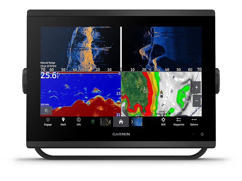
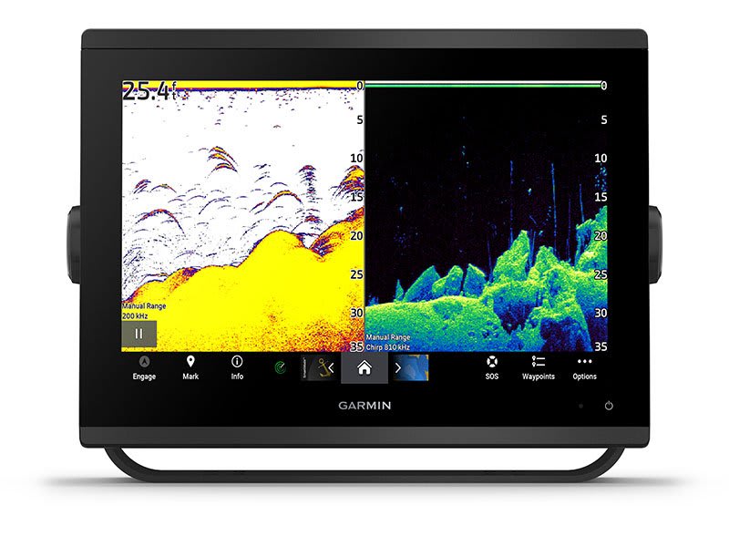
Sonar Features &
Specifications
|
|
CHIRP SONAR
TECHNOLOGY
|
Yes (with
external black box, sold separately)
|
|
CLEARVü
|
Yes (with
external black box, sold separately)
|
|
SIDEVü
|
Yes (with
external black box, sold separately)
|
|
Connections
|
|
NMEA 2000®
COMPATIBLE
|
Yes
|
|
NMEA 0183
INPUT PORTS
|
1
(Differential)
|
|
NMEA 0183
OUTPUT PORTS
|
1
(Differential)
|
|
VIDEO INPUT
PORTS
|
1 BNC
|
|
WIRELESS
CONNECTIVITY
|
Yes
|
|
J1939
COMPATIBLE
|
Yes
|
What's In The Box?
- Chartplotter
- microSD preinstalled
- Power cable
- NMEA 2000 T-connector
- NMEA 2000 drop cable
- Bail mount with knobs
- Flush mount kit with gasket
- Protective cover
- Trim piece snap covers
- Documentation
- GPSMAP x3 chartplotters are preloaded with Garmin Navionics+ offshore, coastal, and inland water charts for the U.S. and Canada
|


