|
|


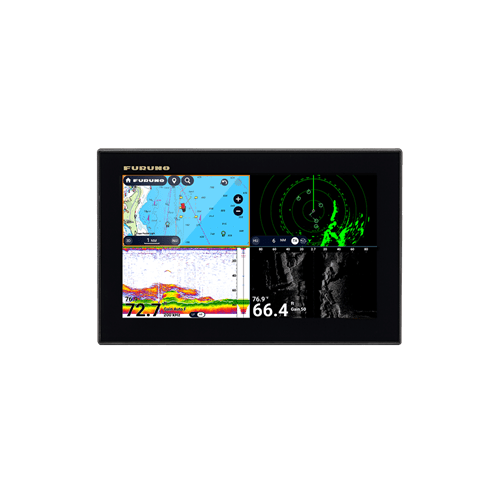
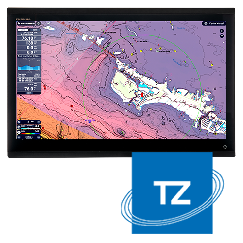
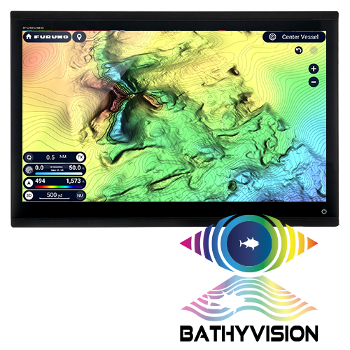
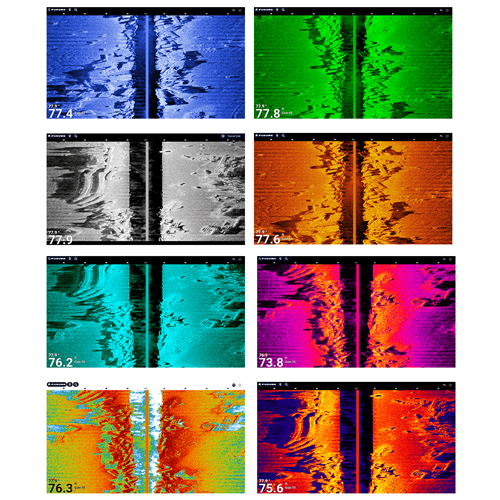
| Compatible Accessories Furuno DRS2DNXT 19" Solid-State Doppler Radar 48nm with Target Analyzer & Fast Target Tracking (No cable included)  Furuno DRS4D-NXT Solid-State Doppler Radar  Furuno 526T-HDD 50/200 KHz High Performance Bronze 1kw Transducer with Temp & High Speed Fairing Block  Furuno 50/200Khz 1Kw In-Hull Transducer 10 Pin 527ID-IHD  Furuno 525TID-TMD (TM258), 50/200 KHz Transom Mount 1Kw Units  Furuno TM260 Transom Mount, 50/200 KHz, 1Kw Transducer with Temperature  Furuno 1Kw, 50/200 KHz Bronze Thru Hull with Temp & High Speed Fairing Block 525TID-BHD  Furuno 50/200 KHz Transducer In Hull 520-IHD  Furuno 556TID-HDD, 50/200 KHz 1Kw Stainless Steel with Temp & with Fairing Block  Furuno 520-5PSD, 50/200 KHz Nylon Thru Hull Depth Transducer  Furuno 520-PLD, 50/200 KHz Nylon LP Depth For 6100-600L-582L-16&1850Df  Furuno 525-5PWD, 50/200 KHz Transom Mount Depth Only Transducer  Furuno 520-5MSD 50/200 KHz Bronze Thru Hull Transducer 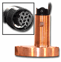 Furuno 525ST-MSD 600W Bronze Multi Transducer 50/200Khz with Fairing Block  Furuno 525STID-PWD, 50/200 KHz, Transom Mount Multi Transducer  Furuno 525T-BSD Transducer with Temp Furuno 556TID-HDD, 50/200 KHz 1Kw Stainless Steel with Temp & with Fairing Block  Furuno ST-02MSB Bronze Speed/Temp Transducer  Furuno ST-02PSB Transducer with Speed/Temp  Furuno CA200B-5S 200Khz Rubber Coated Transducer For 1Kw Units  Furuno CA50/200-12M, 50/200 KHz Bronze Thru Hull High Performance Transducer For 1Kw Units  Furuno CA50/200-1T 1Kw Rubber Transducer  Furuno CA50B-6B Rubber Coated Transducer 50 KHz For 1Kw Units  Furuno CA50B-6G Rubber Coated Transducer 50 Hz with Fairing Block For 1Kw Units  Furuno B164 Bronze Thru-Hull, Low Profile Transducer with Temp, 1Kw 50/200 KHz (10-Pin) 526TID-LTD12  Furuno B164 Bronze Thru-Hull, Low Profile Transducer with Temp, 1Kw 50/200 KHz (10-Pin), 20° 526TID-LTD20  Furuno Air-033-333 Transducer Pigtail with 10 Pin Connector  Furuno Bronze Thru-Hull Multisensor 50/200 KHz with 7" Stem, 600W 525STID-MSD7  Airmar B75C-0-H Broadband CHIRP, Depth & Temperature Thru-Hull 0 Deg Tilted  Airmar B75C-0-L Broadband CHIRP, Depth & Temperature Thru-Hull 0 Deg Tilted  Airmar B75C-0-M Broadband CHIRP, Depth & Temperature Thru-Hull 0 Deg Tilted  Airmar B75C-12-H Broadband CHIRP, Depth & Temperature Thru-Hull 12 Deg Tilted  Airmar B75C-12-L Broadband CHIRP, Depth & Temperature Thru-Hull 12 Deg Tilted  Airmar B75C-12-M Broadband CHIRP, Depth & Temperature Thru-Hull 12 Deg Tilted  Airmar B75C-20-H Broadband CHIRP, Depth & Temperature Thru-Hull 20 Deg Tilted  Airmar B75C-20-L Broadband CHIRP, Depth & Temperature Thru-Hull 20 Deg Tilted  Airmar B75C-20-M Broadband CHIRP, Depth & Temperature Thru-Hull 20 Deg Tilted  Airmar SS75-H-0 CHIRP Thru Hull Transducer with 0 Deg Tilt  Airmar SS75-H-12 CHIRP Thru Hull Transducer with 12 Deg Tilt  Airmar SS75-H-20 CHIRP Thru Hull Transducer with 20 Deg Tilt  Airmar SS75-M-0 CHIRP Thru Hull Transducer with 0 Deg Tilt  Airmar SS75-M-12 CHIRP Thru Hull Transducer with 12 Deg Tilt  Airmar SS75-M-20 CHIRP Thru Hull Transducer with 20 Deg Tilt  Airmar B175C-0-H Broadband CHIRP, Depth & Temperature Thru-Hull 0 Deg Tilted  Airmar B175C-0-HW Wide Broadband CHIRP, Depth & Temperature Thru-Hull 0 Deg Tilted  Airmar B175C-0-L Broadband CHIRP, Depth & Temperature Thru-Hull 0 Deg Tilted  Airmar B175C-0-M Broadband CHIRP, Depth & Temperature Thru-Hull 0 Deg Tilted  Airmar B175C-12-H Broadband CHIRP, Depth & Temperature Thru-Hull 12 Deg Tilted  Airmar B175C-12-HW Wide Broadband CHIRP, Depth & Temperature Thru-Hull 12 Deg Tilted  Airmar B175C-12-L Broadband CHIRP, Depth & Temperature Thru-Hull 12 Deg Tilted  Airmar B175C-12-M Broadband CHIRP, Depth & Temperature Thru-Hull 12 Deg Tilted  Airmar B175C-20-H Broadband CHIRP, Depth & Temperature Thru-Hull 20 Deg Tilted  Airmar B175C-20-HW Wide Broadband CHIRP, Depth & Temperature Thru-Hull 20 Deg Tilted  Airmar B175C-20-L Broadband CHIRP, Depth & Temperature Thru-Hull 20 Deg Tilted  Airmar B175C-20-M Broadband CHIRP, Depth & Temperature Thru-Hull 20 Deg Tilted  Furuno TM150M Medium CHIRP Transom Mount Transducer  Airmar B150M Medium Frequency 95-155 kHz, 0 Deg Tilt CHIRP Transducer  Airmar B150M Medium Frequency 95-155 kHz, 12 Deg Tilt CHIRP Transducer  Airmar B150M Medium Frequency 95-155 kHz, 20 Deg Tilt CHIRP Transducer 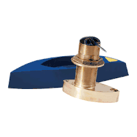 Furuno B785M Bronze Thru-Hull Chirp Transducer with High Speed Fairing Block  Furuno SS75M Stainless Steel Thru-Hull Chirp Transducer - 12deg Tilt - Med Frequency  Furuno SS75M Stainless Steel Thru-Hull Chirp Transducer - 20deg Tilt - Med Frequency  Furuno TM185M Medium-Frequency CHIRP Transducer with Temperature & Stainless Bracket  Furuno B285M Medium-Frequency CHIRP Transducer with Temperature - Bronze Thru-Hull with High Speed Fairing Block 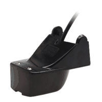 Airmar TM165HW High Wide Chirp Transom Mount Transducer  Airmar TM185C-HW Single Band CHIRP Transducer, No Connector  Airmar B285C-HW Single Band CHIRP Transducer  Furuno Thru-Hull Side-Scan Transducer 12-Pin for TZtouch3 12, 16 & 19 Models, 225T-SS904  Furuno Side Scan Transom Mount for TZT3, 225T-TM904  Furuno Side Scan Paired Thru-Hull Transducers for TZT3, 225T-PR904  Furuno 455T-TM903 Side-Scan Transom Mount Transducer 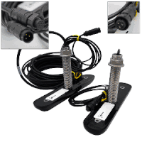 Furuno 455T-PR903 Side-Scan Thru-Hull Transducer Pair  Furuno 455T-SS903 Side-Scan Stainless Steel Thru-Hull Transducer |
Our Company Policy | Privacy Policy | Shopping Cart
Copy Right: WMJ Marine Corporation 2004-2026 |