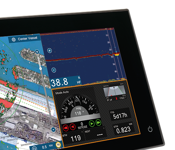
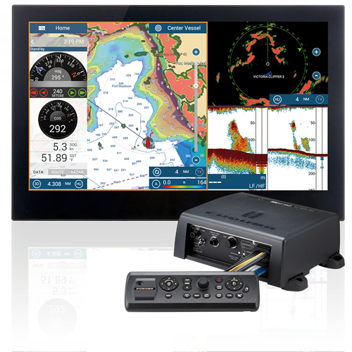
Furuno NavNet TZtouch2 Black Box Chartplotter/Fishfinder TZT2BB
Total Control, simply refined
With the ability to drive multiple monitors with full HD HDMI video output
in any combination of monitor aspect ratios (4:3 and 4:3, 16:9 and 4:3, or
16:9 and 16:9), a refined graphical user interface, and a built-in
RezBoost Fish Finder, Furuno's NavNet TZtouch2 Black Box is a beauty to
behold and use. Whether you are searching for hot fishing grounds,
plotting your next route, or using your Radar to navigate through fog,
NavNet TZtouch2 delivers smooth operation with familiar touch gestures.
*TZT2BB shown with optional monitors
and MCU005 controller
Simply refined, simply beautiful
Following in the footsteps of the original NavNet TZtouch, TZtouch2
features a refined user interface that is all about usability. Elegantly
designed, NavNet TZtouch2 allows you to build a navigation suite that is
not only functional, but offers a luxurious look and feel. Taps,
swipes, pinches, and custom multi touch gestures are instantly transformed
into action, giving you full control of every component connected to your
network.
Incredibly easy-to-use controller andgraphical
user interface
The optional MCU005 NavNet TZtouch2 Black Box controller enhances the
built-in Multi Touch graphical user interface, and sets a new benchmark
for "easy to use" in the marine electronics industry. This interface is
not only intuitive, but is as easy to use as the phone in your pocket. The
combination of an ergonomically designed, logical controller, along with a
touch-screen Graphical User Interface, make operation simple. With taps,
slides and swipes, you will be up and using your TZtouch2 in no time at
all. Menus and other features slide out from each of the sides of the
screen, ensuring that the most important tasks are literally right at your
fingertips.
The available
MCU004 Remote Control option features a large rotary knob which can be
utilized for zooming in/out, while the joy stick allows you to pan around
the chart and move the cursor on the screen. The MCU004 remote has 8
dedicated buttons that operate different functions, such as Edge Swiping,
Home, Stand By/Auto for Autopilot control, MOB, and Center on vessel.
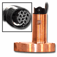
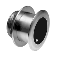
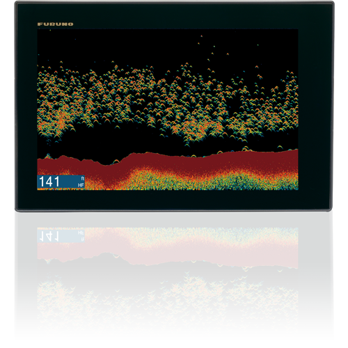
Powerful Fish Finder with built-in Furuno features
The built-in Fish Finder is a dual-frequency (50/200kHz), 600W/1kW power
output sounder. It includes Furuno�s unique Bottom Discrimination and
AccuFish modes, and also incorporates another new Furuno proprietary Fish
Finder technology, called RezBoost. RezBoost is a revolutionary new
feature that utilizes Furuno�s exclusive digital signal processing
protocol to produce fantastic target resolution and separation, without
the need to change out your transducer, or purchase expensive broadband
transducers. With RezBoost, you can now achieve target separation and
resolution that was previously limited to Furuno commercial-grade Fish
Finders.
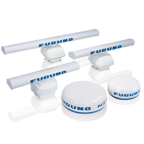
Freedom to build the helm of your dreams
NavNet TZtouch2 is a component-based system that utilizes Furuno�s award
winning network products. You can add a variety of UHD Radars, from a 4kW
NXT Dome up to a 25kW X-Class Open Array. As with NavNet TZtouch, you can
integrate, display, and control the NavPilot Autopilot, and Furuno�s FI70
Instrument. Both of these products have displays that match TZtouch2,
giving your helm a beautiful all-glass finish. Additional sensors that can
be added to the network include AIS, Weather Fax, Sirius/XM Satellite
Weather, Fusion Marine Stereo, and IP Cameras, as well as NMEA2000 and
Furuno CAN bus devices. It even includes one NMEA0183 output port to send
data to legacy systems.
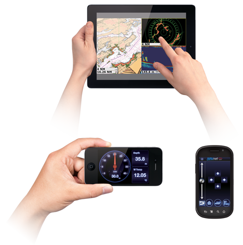
Remotely view and control your bridge with apps for your
smartphone and tablet
Engineered to utilize the latest technology, NavNet TZtouch opens the door
to cutting edge WiFi features, such as tablet and smartphone apps, points
of interest (POI), real time weather data, software updates and more. Take
full control of your NavNet in a whole new way. The TZtouch Remote app
allows you to operate your system remotely with your smartphone or tablet
over WiFi, when connected to the network.
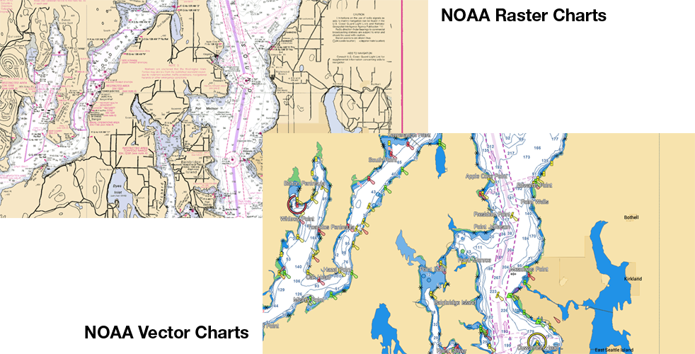
MapMedia Raster
and Vector Chart Library
Freely choose the charts that fit your individual needs and preference.
MapMedia's NOAA Raster and Vector charts for the U.S. Coasts, Gulf of
Mexico, Alaska and Hawaii come pre-loaded. In addition, MapMedia brings
you free satellite photos and detailed fishing bathymetric charts that can
be download for the U.S. Outside of the U.S., "C-MAP" vector cartography
can be purchased and downloaded to your NavNet with ease. MapMedia
cartography integrates cutting edge algorithms with high resolution image
processing techniques to deliver a fusion of digital navigation charts and
satellite photography.
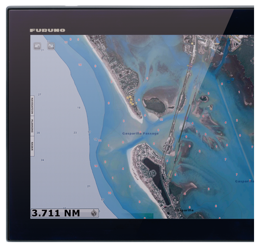
Satellite PhotoFusion� offers a birds-eye view without
obstruction of critical data
You can load any two ultra-wide high-resolution satellite photo areas at
your convenience. Land areas (zero depth) are completely opaque, so these
areas are displayed as high-resolution satellite photos on the chart. As
the depth increases, the satellite photography becomes more transparent.
This allows you to see where the shallows end and the deeper water begins,
while still allowing the raster or vector chart to be visible.
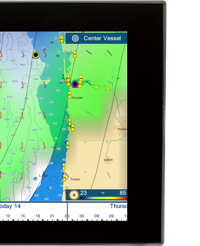
Free & easy-to-use marine weather forecasts
The weather tool is completely free and easy to use, giving you unlimited
access to weather forecasts worldwide 24 hours a day provided by NavCenter.
Select geographic coverage, data type, period of time, and then choose how
to receive the file. NavNet TZtouch2 provides up to 16 days of weather
forecasting.
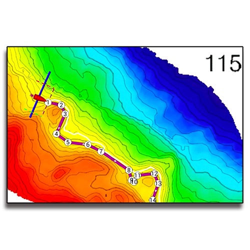
Follow-It instantly creates a constant-depth route!
The amazing Follow-It feature leverages the power of PBG (Personal
Bathymetric Generator) from your DFF3D Multibeam Sonar to instantly create
a constant-depth route to navigate a specific depth contour. With just a
swipe and tap, Follow-It creates a white line on the PBG chart indicating
the constant depth. Tapping the line instantly transforms it to an active
route, sent directly to your NavPilot Autopilot. NavPilot will follow the
depth route all the way around a ridge or trough. By following specific
depth contours, fishermen can keep their baits at the same level as the
fish while trolling without constantly adjusting the reels. Having your
bait at the correct depth is critical to catching fish in areas where tide
and currents flow along structure where gamefish concentrate.
Display Unit
Type
Color LCD with
touch panel control, FHD 1920 x 1080 recommended, XGA 1024 x 768/SXGA
1280 x 1024 available, sold seperatly
**The price is subject to change at anytime without any notice. We
are not responsible for any typographical errors. Any products can be
cancelled from sale at any time.
** All Products sold here are Brand New unless specified
Otherwise and come with Full Manufacturer's Warranty
WARNING:
This product can expose you to chemicals including Di-n-hexyl Phthalate (DnHP)
which is known to the State of California to cause reproductive harm, and
Vinyl Chloride which is known to the State of California to cause cancer. For
more information go to P65Warnings.ca.gov.
__________________________________________________________________________________________


